|
I am a big fan of GPS or the Global Positioning System. I appreciate the guidance it provides for a directionally challenged individual. When you stop to think about it , it's amazing all of the processes that are occurring behind the scenes for that to happen. Many have gotten accustomed to asking Siri or Alexa how to get to their destination. While this is helpful, it's low level of difficulty makes it unlikely to be remembered. To prevent that from happening, or at least reduce the risk, we wanted to give students a more behind the scenes hands-on experience with this concept. Students had been exploring how light and sound waves travel and how this impacts us. The focus of our investigation was on how a GPS uses this to determine a location. The set-up consisted of six stations that students completed over two consecutive days. They were provided with several resources of different types to make sure they understood what a GPS was and how it worked. Students were able to take notes, answer questions and create sketchnotes to document their findings. Then, we put the kiddos in action on the Mars Map as GPS signals. Video ClipsA great NASA SpacePlace video narrated by a kid that explains GPS in a context kids will understand and be interested in...ordering pizza!
Articles
Before unleashing the students, we prepped the satellites. We taped string to three different places around the room. We named each of the three satellites - Mercury, Gemini and Apollo respectively - and marked a set distance on each string. Each team was given a task card with a scenario and distance for each of the three satellite signals. With this information, students had 10 minutes to pinpoint an absolute location on Mars using a meter stick. We came up with 6 different scenarios, so no team was trying to find the same location. Note: Attaching the satellite signals to the wall and measuring was a lot more difficult that it sounds. We quickly found that the string we were using kept getting tangled. So, I would recommend using rope or at least a thicker string. 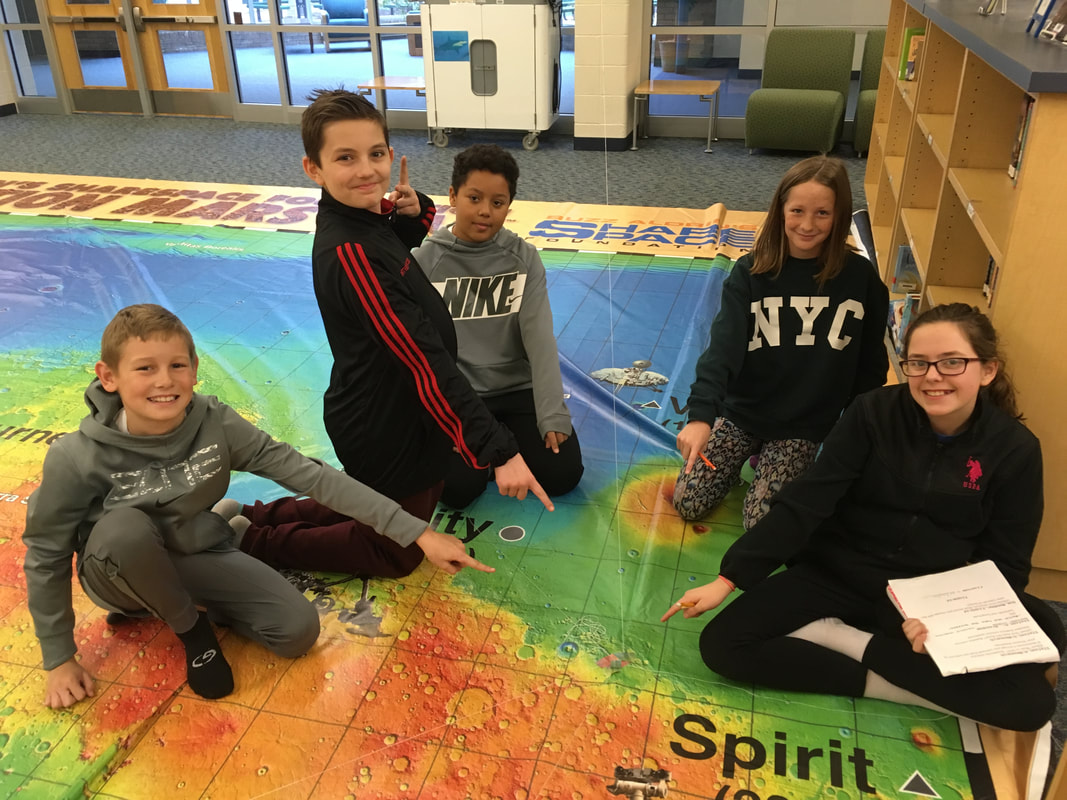 The winning team was able to correctly identify the coordinates based on the convergence of the three satellite signals. Even though the word globe can refer to any spherical object, it is generally used to represent the Earth. The culmination of the investigation was for students to determine what a GPS used on Mars should be called. Would the title Global Positioning System fit for that purpose or not? I'll leave you to ponder that thought...
Peace, love and space exploration, CAPCOM Conrad
0 Comments
Whenever I hear the word satellite, I think of this song, Cecelia and the Satellite by: Andrew McMahon. Background Satellites are extremely useful tools that allow us to learn more about Earth- especially weather, precipitation, landforms - from a slightly different perspective. Satellites see things in pixels aka picture elements. 1 pixel = 1 square area on an image. Spacecraft use 8-bit data. This means that a computer can have 256 shades of gray...talk about being in a gray area! Binary code - series of 0s and 1s that tell a computer information - also comes into play. The binary numbers are used to determine the shade of grey represented. Later, a person interprets the shades of grey as colors and assigns colors to the images. These related Brainpop videos give more information about the topics and include activities, games, a quiz and a link to Newsela articles to read more! Comparing Pixel SizesAs the pixel size decreases, the resolution increases, making it easier to determine what the picture is. Part 1 (Larger Pixels) - Students put the colored paper in the grid square that has the corresponding number. 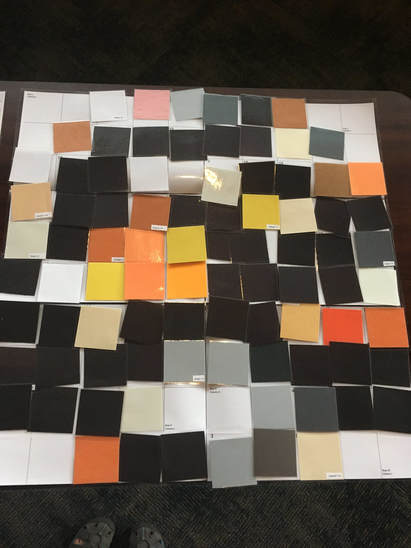 Part 2 (Smaller Pixels) - Students sort the pre-filled in grid segments to make a large grid. 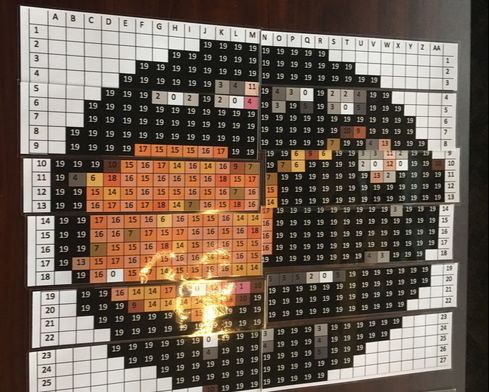 Can you guess what it is? Part 3 will be revealed tomorrow! Binary COde GridingOverview
Code
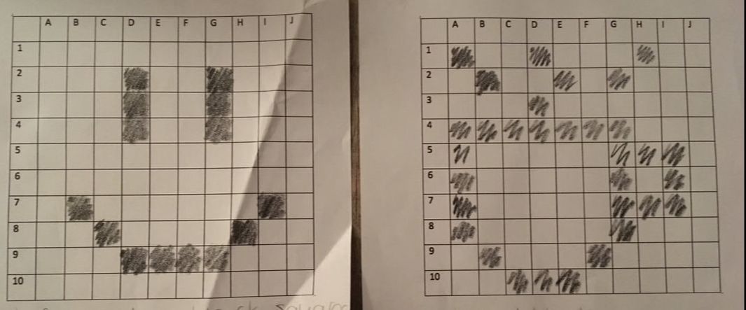 Some binary code grid examples. The code for the first row on the smile was all zeros. The code for the first row on the coffee cup was 1 0 0 1 0 0 0 1 0 0 . Roles -> Switch after a grid is completed.
Materials
1. Satellite choses one laminated grid from envelope, keeping it concealed from group members. 2. Satellite describes grid in binary code ONLY. Satellite should NOT tell group what image he/she sees on the grid. 3. Satellite can decide to go pixel by pixel or focus only on the shaded squares. 4. Each Computer receives a blank grid and black crayon or colored pencil. The Computers color in the grid squares based on the Satellite's directions. After the Satellite's directions are complete, Computers can determine image. 5. If group has an Engineer, he/she will get a blank grid. Using the computer's image, he/she will assign colors to black squares and recreate the image in color. 6. Roles switch and above steps repeat. How can I adapt? - Change the pixel images to fit something you're studying in class! - Have students design pixel images. Laminate and use them for the activity instead of printed or copied ones. - Divide a large pixelated image into smaller grids. Give each group a grid. Have all groups combine grids to determine overall image. - Have students determine fractions, decimals, percentages and ratios of shaded and unshaded pixel grid squares. This simple, fun activity is a great way to integrate art, technology, math and space into your classroom!
Peace, love and space exploration -CAPCOM Conrad |
AuthorApollo 13 fan. Educator. Lifelong Learner. Third generation Boilermaker. Space Exploration Enthusiast. Collaborator. 
Click Subscribe to stay updated!Archives
July 2022
Categories
All
|
 RSS Feed
